Asia Minor GNSS Network Project
FIRST CROSS-BORDER GNSS NETWORK FOR MONITORING TECTONIC PLATES
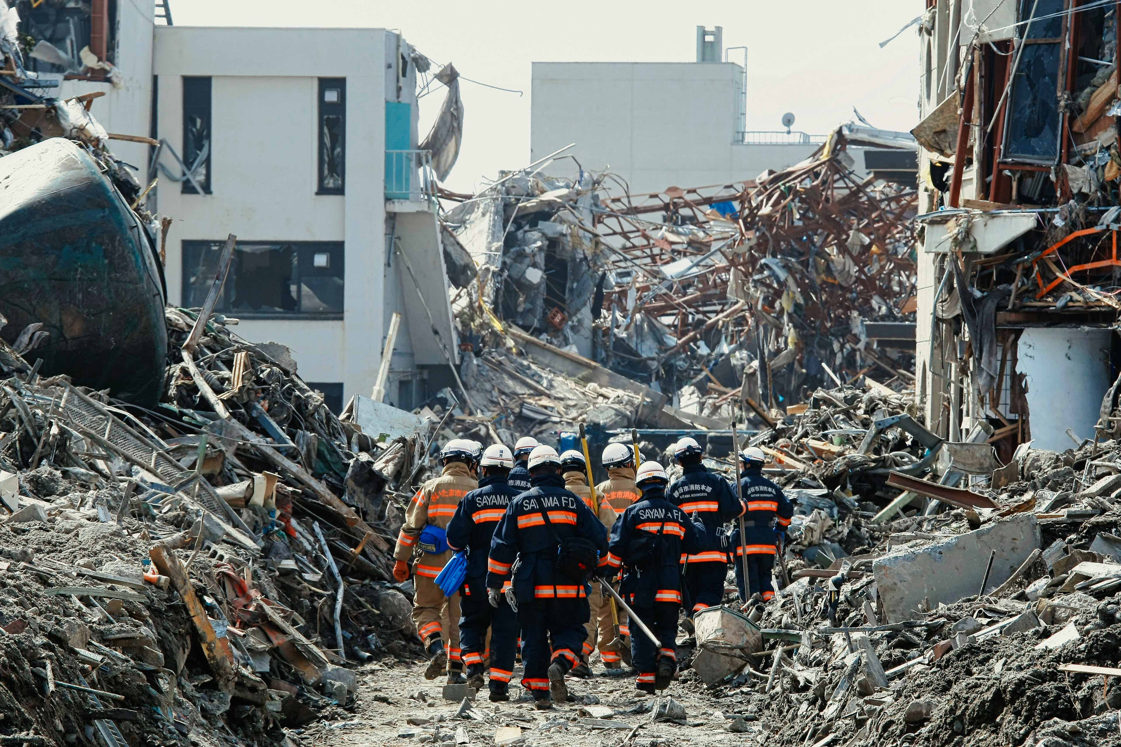
In response to the devastating earthquakes that struck Turkey and Syria in February 2023, Texplor Geontech is committed to making a significant contribution to the disaster response efforts in the Asia Minor region.
To this end, we have launched the “ASIA MINOR GNSS NETWORK” project, which involves the immediate deployment of a GNSS network for all affected countries.
With the new TEXtant® GNSS network, it will be possible for the first time to observe the crustal movements of several plates simultaneously and to evaluate them daily. In combination with current seismic results, this opens up completely new possibilities for the development of an effective early warning system for the entire affected region.”
Ernst Geutebrück, PhD, CEO

ASIA MINOR SEISMIC RISK AREA
High risk because of unpredictable crustal plate tectonic movements
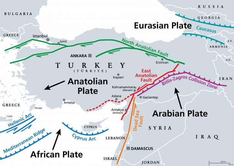
Asia Minor, also known as Anatolia, is in a highly active seismic region, known as the Mediterranean-Asian or Alpine-Himalayan belt. The convergence of the Eurasian and African tectonic plates generates significant strain on earth’s crust, resulting in frequent and severe earthquakes. These earthquakes can cause widespread damage and loss of life, making it crucial to take steps to mitigate the risks and prepare for the possibility of an earthquake. Such steps can include developing earthquake-resistant structures, and early warning systems, and educating people on what to do in the event of an earthquake.
- High level of seismic activity
- Eurasian and African tectonic plates shifts, causing frequent earthquakes
- Destruction and loss of life from earthquakes are inevitable
We are deeply aware of the devastation caused by natural disasters and the importance of prevention and preparedness. We recognize that crustal plate movements are one of the primary causes of earthquakes, and it is essential to monitor them to understand the potential risks and take proactive measures to prevent such disasters from happening again.”
Bastian Merten, MSc, CTO

URGENT NEED FOR A NEW GNSS NETWORK
In the Asia Minor region, a significant challenge is the lack of an existing GNSS network. The current results are not in real-time and require processing, causing delays in receiving critical information after an earthquake. Moreover, IGS stations are not connected with each other, further hampering the monitoring process. Therefore, a dedicated GNSS network system for the entire region is urgently needed to provide reliable and accurate data in real-time and enable effective disaster response.
SOLIDARITY AND RESPONSIBILITY
Texplor Geontech is in solidarity with the people affected by the recent natural disaster in the region of Asia Minor caused by the severe earthquakes. We believe that it is our responsibility as global citizens to support humanity in times of crisis, regardless of their ethnicity or affiliation.
Our sympathies go out to all those who have suffered from this tragedy. I am convinced that our TEXtant® GNSS network technology will be critical in saving lives and reducing the damage caused by earthquakes by improving earthquake monitoring and early warning systems.”
Ahmed Elsaid, BSc, MSc, Head of research and development

THE TEXTANT GNSS NETWORK DONATION PROJECT
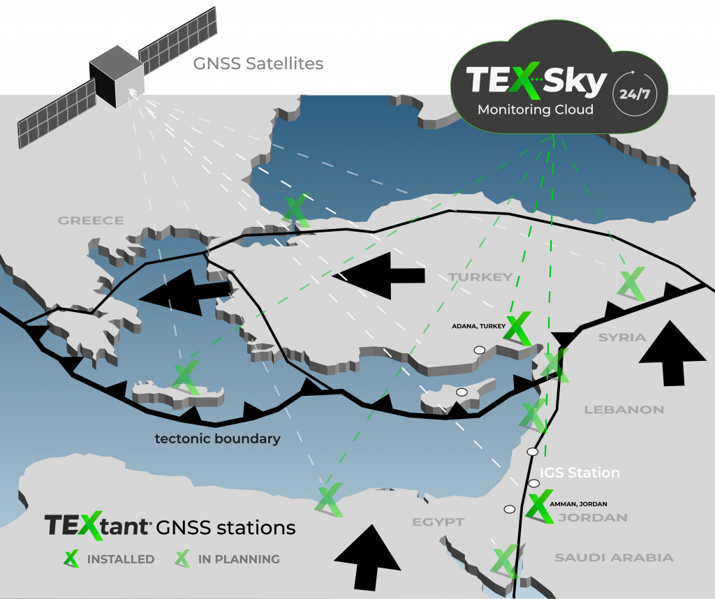
Our project aims to establish a network of 6-7 TEXtant® GNSS systems in the Asia Minor region, covering countries such as Turkey, Syria, Lebanon, Saudi Arabia, Egypt, and Jordan, to monitor daily crustal plate movements. We are committed to donating this first startup GNSS network to aid in disaster prevention and preparedness efforts in the affected region.
The installation of the TEXtant® GNSS network system in key locations throughout the region will provide researchers and emergency management authorities with a reliable network of monitoring equipment. This will help to identify potential earthquake hazards and provide warning to those in affected areas. Our goal is to establish an effective and networked early warning system for earthquakes to protect people and regions affected by upcoming earthquakes.
The project description includes setting up an early warning system for all affected countries, with daily X, Y, and Z data results available for all experts of neighboring countries. This will be achieved through the installation of a base network of 6 – 7 TEXtant® GNSS monitoring stations across the region, providing reliable and up-to-date data for emergency response teams to assess the risk of possible aftershocks.
- Set up a TEXtant® GNSS network for the affected region
- Donation of 6-7 TEXtant® systems for startup network
- Daily visualization of results for experts of all participating countries
In conclusion, the TEXtant® GNSS movement monitoring network will significantly contribute to disaster prevention and preparedness efforts in the Asia Minor region. The daily monitoring of crustal plate movements and early warning system for earthquakes will help protect lives and minimize damage in the event of an earthquake.
NEW STATE-OF-THE-ART GNSS TECHNOLOGY
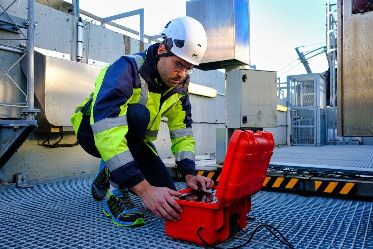
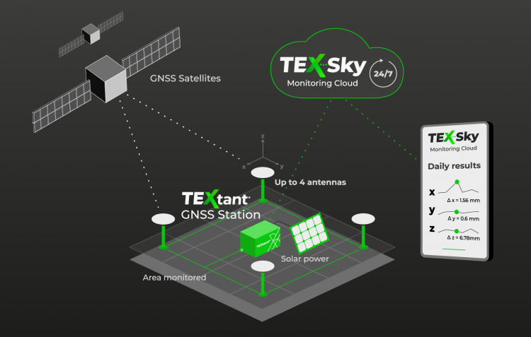
Introducing TEXtant® – a new GNSS network with state-of-the-art technology for movement monitoring. Its stand-alone device can take precise measurements in remote and inaccessible locations, providing daily results on crustal activity in the Asia Minor region. The cloud-based system connects all countries in the area, allowing data to be shared and accessed by researchers and emergency management authorities, improving collaboration and coordination in the event of unusual crustal movements. The automated Global Satellite Navigation System can monitor crustal plate movements 24/7, providing comprehensive understanding of potential risks and aid in disaster prevention and preparedness.
- Precise monitoring crustal activity with millimeter accuracy
- Cloud-based network enables daily sharing of results with experts and researchers
- Improves collaboration and development of effective early warning systems
TESTED AND PROVED IGS ACCURACY AND RELIABILITY
The TEXtant® system has successfully demonstrated its capabilities in movement monitoring at the Aquitaine bridge project in France, operating 24/7. The system was also tested at the IGS station in Geoforschungszentrum (GFZ) Potsdam, Germany and has demonstrated millimeter-scale accuracy equivalent to the IGS station. These successful tests have proven the system’s efficacy, making it ready for deployment in disaster-prone areas to aid in disaster prevention and preparedness.
PROJECT SCHEDULE
EARTHQUAKE IN TURKEY AND SYRIA
6th of February 2023
PROJECT START
Presentation and Donation of TEXtant® GNSS Network / March 2023
FIRST INSTALLATIONS
Adana, Turkey / April 2023, and Amman, Jordan / May 2025
SETUP THE NETWORK
Next installations in Egypt, Lebanon, Syria, and Saudi Arabia / 2025-2026
NETWORK COMPLETED
6-7 GNSS stations are online / 2026
EXPANSION
Installation of additional TEXtant® GNSS systems in other locations across the Asia Minor region and other risk areas in the world
JOIN US AND CREATE THE NETWORK WITH US
We believe in the power of cooperation to overcome catastrophes that affect humanity beyond borders. We’re excited to launch the TEXtant® GNSS movement monitoring network and collaborate with researchers and emergency management authorities in Asia Minor to enhance disaster preparedness and response. Our cutting-edge GNSS network system through the ASIA Minor GNSS project will contribute to the region’s safety and security. The solution also involves inspiring others to join us in our efforts to make a meaningful contribution to the disaster response efforts in the area. Together, we can work towards overcoming catastrophes that affect humanity as a whole, beyond national borders.
Join us and be part of the solution!